Salem History Matters

  • Welcome!
  • Our History Blog
    • EPISODE LIST
  • Spotlight on History
  • Links We Like
  • Contact Us


WE'VE GOT A LOT WE WANT TO SHARE!
 
​HOW ABOUT YOU?

Download A Podcast

Researching Public History: Christy Van Heukelem & Kimberli Fitzgerald

2/6/2020

0 Comments

 
Picture
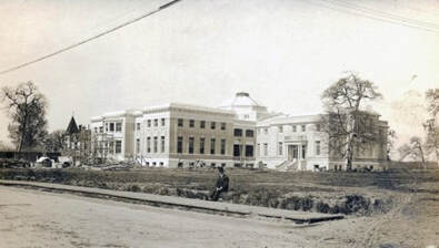
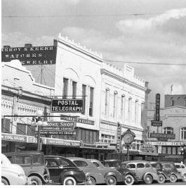
Oregon State Hospital "North Campus" 1912. The Glen Oaks Orphan's Home with its turret is at far left, the new Receiving Ward is under construction, and the Dome Building is just behind and to right. [Photo: OSH Museum/Christy Van Heukelem]
January 23, 2020 episode.

Historians are hired to research a wide variety of topics for their clients. Typically it is the lineage of a family, or the history of a property or an organization. Occasionally research is needed to clear up a question involving a property and its relationship with another.  This was the case with a parcel that was part of the Oregon State Hospital grounds that required the expertise of Kimberli Fitzgerald, the City of Salem's historic preservation officer, and our own research bulldog, co-host Christy Van Heukelem.

Picture
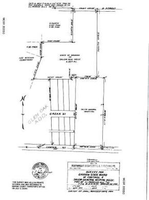
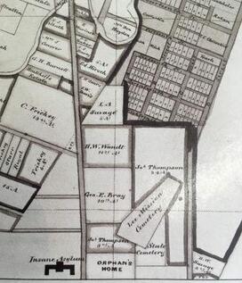
Salem & Suburbs Map, c1892, showing Insane Asylum, lower left, Orphan's Home, across Center Street to the right, with the State Cemetery and the Lee Mission Cemetery adjacent. [Photo: CVH]
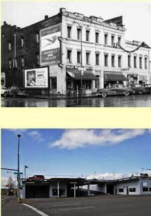
The OSH properties to the north of Center Street, east of 24th Street, are called the North Campus. Other than the Dome Building, a recognized historic resource, the other buildings were demolished in recent years.  The building at the far left of the photograph above is the 1887 Glen Oaks Orphan's Home.

This parcel was originally part of the Josiah L. & Elizabeth Winn Parrish donation land claim. The Parrish family donated 10 acres to the Oregon Children's Aid Society in the 1880's for construction of the orphan's home, as well as several adjacent acres to the northwest for construction of the Lee Mission Cemetery.  The Glen Oaks Orphan's Home was sold to Salem Hospital in 1887, and Salem General Hospital opened there in 1889.

Picture
Picture
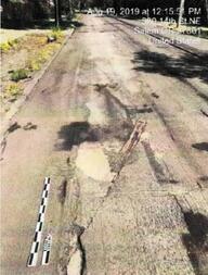
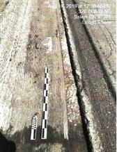
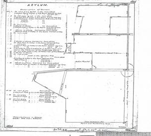
Land Survey Map, c1900 (above) showing State Hospital plat; inset highlights original cemetery site [Photo: CVH]
Now that the State of Oregon has removed the previous buildings from the North Campus property, they wished to sell the property to the City of Salem. The Confederated Tribes of the Grand Ronde notified the State that they had questions as to whether any remains of Native American patients were still interred in the cemetery  once located on this site.

The State contended that the remains were disinterred in the early 1900s and then cremated, but records to substantiate that claim could not be located. The State then hired specialists to dig test holes at the site they had originally identified as the cemetery, but nothing was found. Ground-penetrating radar (GPR) was also utilized but found no conclusive evidence of any remains either.
​
This is where Christy enters the story, when the State hired her to research available records to find documentation that might substantiate the record regarding the disposition of these remains. This project proved to be a three-month-long endeavor, with Christy logging more than 170 hours in dogged research, including perusing pages of old newspaper accounts, questioning the record-keepers for period mortuaries, sifting through property transfer documents, even reading the numerous pages of a few Oregon State Board of Control Biennial Reports to the Legislature as she attempted to  "follow the money."

Although she did find records of the purchase and installation of a crematory on the grounds of the Asylum, she was unable to locate any documents verifying that the remains were actually disinterred and cremated, However, she also found no documentation that any graves or remains were discovered during the years of subsequent redevelopment on this site. 
Picture
Boatwright Engineering Survey Map, Oct. 1950, showing the parcel sold to Salem General Hospital by the State of Oregon. [Photo: CVH]
Picture
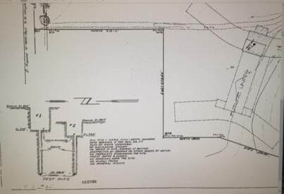
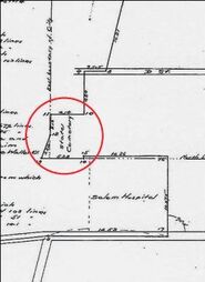
This is a close-up view from an accompanying 1950 Boatwright Eng. survey map of the relevant area showing the proposed building location and the two test pit specifications. [Photo: CVH]
Christy was able to ascertain that the cemetery probably extended farther than originally believed. She located 1950 survey maps from Boatrwright Engineering done prior to the construction of the Morse Building-Maternity Unit for Salem General Hospital on land recently purchased from the State, that demonstrate the boundary being farther west. An ArcMap Plot Map obtained from the City of Salem taken before the hospital's demolition in 2017-18 show the proposed building fully constructed on the site.
Picture
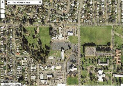
The City of Salem's ArcMap Plot map taken prior to 2017 shows the constructed building in place, center. Lee Mission Cemetery is in the left center, Salem General Hospital, lower center, and Dome Building at lower right. [Photo: CVH]
Unfortunately, unlike the mystery and genealogy shows we view on media today, no definitive answer to the original question was obtained. The only conclusion Christy was able to develop was that at least a portion of the Asylum cemetery was located at a different site than was tested, either with the new test pits or the ground-penetrating radar.  It will be left to subsequent property owners and their researchers to ultimately determine if there are any remains in that specific area.​
As so often happens when doing in-depth research, additional questions present themselves more often than real answers. Although it can be quite frustrating at times, we have to admit that this is often where the "fun" begins--just what treasures will you find in the next book or on the next map?  
To learn more of the details of the very convoluted path Christy followed to attempt to settle this issue, check out the final report she submitted to the Department of Administrative Services and posted on her website, Lineage & Lore.org.  To listen to the podcast of this episode, click here.
~~Posted by Deb Meaghers
0 Comments

Historic Buildings & Businesses: Pomeroy & Keene Jeweler & Optical

12/6/2019

0 Comments

 
PictureNorth side of State Street, 300 Block, c1935 [Photo: JOgdahl coll.]
November 7, 2019 Episode.

The photograph to the left was taken in 1935 from the southwest corner of Commercial and State Streets, the very hub of downtown Salem at the time. This photo has been gracing the walls of Ma Valise Boutique since Janet Ogdahl opened her shop in one half of the historic Pomeroy & Keene Building at 379 State Street in 1995.

​With quite the background in retail endeavors, Janet was drawn to this building, which seemed so "French" in her mind, knowing it would be perfect for her vision of a women's boutique--Ma Valise translates into "my suitcase"--where she could display and sell all the lovely items she found so charming.

PictureJanet Ogdahl at KMUZ Studio, 2019
Janet and Wally Ogdahl purchased a half-interest in the building in partnership with Charles Zawel. Later she was able to acquire the remaining portion of the building from the estate of Audrey Pomeroy Goodwin. Renovations were undertaken to repair and restore the beautiful cabinetry and ceiling of the 1927 renovation, and later restoration was made to the facade. Janet was the recipient of matching grant funds from the City of Salem that enabled her to complete the work in phases, with additional restoration work on the facade to begin soon.

Janet's son Toby operates a restaurant/bar next door at 383 State named W Wallace, after his father; and Toby's wife continues to operate her hair salon, Havana, on the second floor. Janet's daughter Katy took over the shop space this past summer and opened her own boutique, Gatsby, which reflects the time period of the Pomeroy & Keene renovation of 1927. The family stewardship of this well-used building continues.​

Picture
Land Patent (above) and Town Plat (below) courtesy of Ogdahl Collection
Picture
Although the history of the Pomeroy & Keene Building began as the First Gray Building in the 1860s, it has housed a number of businesses, even a rooming house (aka "bordello"), over the years as Salem grew. Janet has acquired a 1925 Title Abstract that traces the ownership of the site back to the land patent granted by President Abraham Lincoln to William Willson, recorded in 1862, and includes a copy of Willson's original 1850 plat for the City of Salem (see photos to left).

The 1925 abstract tracks the property through 1890, depicting changes of ownership nine times over that period. Names of the owners show the diverse ethnic population in those early days, as well as several transactions by folks with names familiar to us to this day: Willson, Powell, Uzafovage, Myers, Meredith, Farrar, Adolph, LaBranche, and Fontaine. The documents include testaments from J.K. Gill and Charles McNary, even some probate records.
We were able to track the businesses of Charles T. Pomeroy, with various partners, back to 1905, but some sources state 1896 or even 1868. It was common for the time to have jewelers provide optical supplies as both used gold and had the delicate tools required, similar to coffin-makers also doing fine cabinetwork. The 1905 City Directory lists him under the "Watches, Clocks & Jewelry" category with an address of 288 Commercial Street. That would be the second block to the north or south of its intersection with State Street (as no direction was listed), probably on the east side due to its even number. Then in 1917, the City Directory lists him in partnership with A.L. Wallace at 125 N. Commercial Street, next to the US National Bank. The same directory lists A. A. Keene in partnership with A.B. Gardner at 386 State Street. 

The 1919 photo below shows Buster Brown Shoes at the Commercial Street address, so Pomeroy had moved his business  again. 
Picture
The United States National Bank (now Pioneer Trust Building) anchors the 100 Block of Commercial Street NE during a snow storm in December 1919, The third storefront to the right, Buster Brown Shoes at 125 Commercial, earlier housed Pomeroy & Wallace Jewelers & Watchmaker in 1917. [Photo: Wilamette Heritage Center-00830060017041]
Charles Pomeroy and Arthur Keene purchased the stock of A. B. Gardner in December 1920, and began their partnership. They announced their assumed business name of Pomeroy & Keene in February 1922, located at the southwest corner of Liberty and State Streets. In August 1923, the newly reorganized Capital National Bank (later First National Bank) announced plans to build a new six-story structure that would cover the ground then occupied by Pomeroy & Keene jewelry store and Red Cross Pharmacy on State Street, and Graber's Plumbing shop on the Liberty Street side--the Capital Center. They're on the move again--across the street to the site of Brownell Electric at 388 State, next to A.B. Gardner's old store.
Picture
[Photo: Willamette Univ. Archive 10-31096-WUA9999-WP-0840-Box7]
Picture
[Photo: City of Salem]
In 1926, Pomeroy & Keene announced plans to remodel the facade of their new location at 388 State Street, taking out permits in the amount of $5000. The business takes occupancy in 1927. The 1934 photo, above left, shows the storefront with their signature clock out front. Note the painted advertisement for "Rooms" still visible on the upper west facade.

By the time of the 1941 photo on the right above, the prosperous business had fully taken over the building and changed the signage appropriately. The "second" Gray Building abuts them to the east. In 1942, their shop was the location for a downtown salvage drive, with a large number of clockworks adding to the piles of metal salvaged for the war effort.

In another of those curious circles-of-life instances that no longer surprise us in our long-lived community, we recall that Holly Jackson, patriarch of the Jackson Jewelers legacy, worked for 13 years as the watchmaker for Pomeroy & Keene before opening up his own shop across the street in the Capital Center in 1944, prior to moving into the location up Liberty Street we know now. Holly even installed a clock that is very similar to the one at Pomeroy & Keene's in front of his new business.
Picture
State Street looking east, 1957 postcard, Pomeroy & Keene next to "blue" Gray Building [Photo:WHC0063001005900307]
Picture
Pomeroy & Keene Jewelers, 379 State, (far left); Pomeory & Keene Bldg rooms, 381 State, and Pomeroy Optical at 383 State; Gray Building far right, c1970 [Photo: WHC 19990130304]
Charles T. Pomeroy, grandson of pioneers Walter John Pomeroy & Elizabeth Geer who came to Oregon as part of the 1842 Elijah White wagon train, died in 1937 at the age of 72. His family operated the business with Arthur Keene, until his retirement in 1950, and then continued the business for many years to follow. Mr. Keene died in 1975 at age 92. 
It is the responsible stewardship of our historic resources, such as evidenced by both the Pomeroy and Ogdahl clans, that preserves the integrity of our historic fabric so that future generations can revel in this rich legacy. Our community is truly indebted to their vision and selflessness.

While interviewing Janet about the Pomeroy & Keene Building, we learned that her family, the Fields and the Ogdahls, have interesting histories in their own rights, and Janet will be joining us again to share that story with us.  Look for her family's story in early 2020!
~~Posted by Deb Meaghers
0 Comments

Historic Main Streets: Revitalizing Our Downtowns - Sheri Stuart & Hazel Patton

11/22/2019

0 Comments

 
PictureSheri Stuart (left) and Hazel Patton, Salem History Matters Show, 2019
November 21, 2019 Episode.

We are privileged to live in an area where preserving the multi-faceted tapestry of our history is important to us. This is especially evident in Salem's downtown core which was designated as a National Register Historic District in 2001.  Recently, folks who are particularly concerned about maintaining a vibrant life in our historic downtown banded together to preserve and promote that area. Hazel Patton, with the Salem Main Street Association, and Sheri Stuart, the coordinator for Oregon's Main Street Program, appeared on our radio program to tell us more about this program and how it can help revitalize the historic downtowns of cities within our state.  

PictureLaunch Party for Salem Main Street Association, March 2016 [Photo: SMSA-FB]
Hazel, a longtime community activist with a deep love of the history of our area, told us that a group of Salem folks who were passionate about the historic downtown area began meeting together a few years ago to brainstorm ideas to improve the vitality and vibrancy of the downtown and riverfront areas. For several years, there had been no cohesive organization to promote and advocate for the downtown core, and the merchants and property owners were feeling this void.  So, in March 2016 these civic-minded folks formally organized under the umbrella of the Salem Main Street Association (SMSA), and chose the Main Street program as the best vehicle to achieve their stated goals. 

Picture
The SMSA is currently comprised of four working committees. The Design Committee’s goal is to enhance the downtown’s visual appeal and its connections to the riverfront through aesthetic-forward design, while creating an inviting pedestrian environment. The Economic Vitality Committee works to strengthen the downtown as the regional shopping, dining, and entertainment center in the heart of the Willamette Valley. The Organization Committee’s goal is to develop a cohesive, strong, sustainably funded organization with downtown stakeholders working together to achieve tangible results. And, most visibly, the Promotion Committee works to create enticing events and marketing strategies to draw residents and visitors to experience vibrant downtown Salem. 

The Promotion committee oversees recurring events such as First Wednesdays and On Your Feet Fridays, among other pop-up events. One of their most recent events celebrated the businesses that have been taking over the downtown alleyways by promoting a contest to name the alleyways within the historic district's downtown core.

SMSA reached out to the Historic Landmarks Commission for some historic background for potential names, and the public voted during downtown events this past summer. Eight of the nine designated alleyways were named, with the ninth name being determined by the Confederated Tribes of Grand Ronde to commemorate our Native American heritage. The City has installed sign-toppers on the street signs, and the alley names will be marked in the concrete being installed as part of planned upcoming street improvements.

To read the HLC report, click here. To view a larger map of the alleys, click here.​
Picture
Salem Alley Days, June 2019 [Photo: SMSA-FB]

Picture
Map Courtesy of City of Salem
Picture[Courtesy of Oregon Main Street Program]
Sheri Stuart advised us that the Oregon Main Street Program is managed by the  Heritage Division of the Oregon Parks & Recreation Department and follows the protocol of a national program administered by the National Main Street Center of the National Trust for Historic Preservation. There are four levels of participation that communities may consider. State staff then assist them in setting up the organizational pieces, such as the formation of a nonprofit corporation, providing technical and grant assistance, and then follows them through the ensuing process. 
​
Currently there are 91 communities all across Oregon participating in the program at one of the four levels. The graphic above denotes those communities participating at the higher levels. For a list of all the participating communities, check out their website highlighted above.

We are so very fortunate that a national organization expended the effort and resources to produce and promote a program that could be the very lifeline for our historic downtowns. If you know of a community struggling with its downtown viability and sense of place, share this information with them. 

Here in Salem, we are grateful for those in our community who have the desire and vision to investigate and then invest in these improvements that will mean a brighter and more secure future for our character-defining historic downtown.

To listen to the full recorded episode, click here.
~~Posted by Deb Meaghers
0 Comments

Historic Preservation Report--Things Are Changing: Kimberli Fitzgerald

11/1/2019

0 Comments

 
PictureWest intersection of Commercial and State Street, snow storm of 1937. Griswold-Murphy Building at left, Pioneer Trust Building at right [Salem Public Library Historic Photo Coll.]
October 24, 2019 Episode.

The area near the intersection of Commercial and State Streets in Salem's downtown core was the first hub of commerce in our early years. This was where you went "to town," and the city soon quickly developed around --and even over--it in the ensuing years. Soon this area within the Salem Downtown Historic District will have a totally different look. Kimberli Fitzgerald, Historic Preservation Officer for the City of Salem, joined us once again to provide an update on current and proposed historic preservation projects happening in our town center.

The parcel at the southwest corner of Commercial and State Street once housed the two-story 1858 Griswold Building/Opera House (the first brick block in Salem), followed by the three-story Griswold-Murphy Building until 1940, and then the newly constructed Murphy Building--until it burned down in 2006. In recent memory, Hogg Brothers' Furniture and McMahan's Furniture were located there, but over the years it has also been home to the Capitol Hotel, the Oregon Statesman newspaper, Les Newman's clothing and shoe store, the New Shanghai Chinese restaurant, Perry's Drugstore and the Schreder-Berg Grocery. In the late 1880s, the Masonic Hall leased space there, and the public library was on the third floor.
Picture
Picture
The 1858 Griswold Building-Opera House, left. The Griswold-Murphy Building c1940, above; [Photos: SPL-HPC]
PictureKoz on State - Nishioka Building will have retail uses along State Street, with the lobby for residential use on Commercial Street. [Rendering: City of Salem]
Now addressed as 260 State Street, a new mixed-use building with retail uses on the ground floor and residential apartments on the upper floors is being constructed.

​Due to its sensitive location, an archaeological monitor was onsite when the brick foundation of the former building was uncovered. The "inadvertent discovery" was documented and the construction work continues. 

Picture[Photo: shineonsalem.org]
Further south on Commercial Street, at the intersection of Ferry Street, is the original site of the Holman Building, later the Marion Car Park & Rental. The history of the original Holman Building is now being given new life in the form of the new Holman Riverfront Hotel.

​As you may recall from earlier stories, the Holman Building was the center of  Oregon state government following the burning of the first Capitol building, from 1857 until 1876 when the second Capitol Building was constructed.

In the before-after photos (left) from the SHINE website, the original Holman Building is seen c1940 (top) and the Marion Car Park, c2000.  

Picture[Rendering of Holman Riverfront Hotel: City of Salem]
The developers  of the Holman Riverfront Hotel plan to showcase  the illustrious history of its namesake in the designs for the interior of the new building. Below is an architectural rending of the proposed building.

Kimberli also advised that there will be a proposal for redeveloping the Laundry Building and water tower at the former Fairview Training Center site coming before the Historic Landmarks Commission in the near future. The new owner is proposeing to redevelop the building into a rollerskating rink and a women's medical facility.

​Another proposal expected soon is for construction of an accessory structure at the historic AC Gilbert Children's Museum site to house the new Bubble House, relocating the ever-popular museum attraction that was closed a few years ago to prevent further damage to the historic building. We'll keep you posted as these proposals move through the City's review processes.
October was Archaeology Month in Oregon, with the focus being on public archaeology. Additional research on the Chinese-American history was presented. Kimberli continues to build her "bone collection" to further enhance the outreach to Salem's school children, as well as to promote interest in future public archaeology projects in the Salem area. We certainly look forward to the opportunities such projects afford our community to learn more about our ancestors and our interwoven history.
PictureAsylum Line trolley sweeps through the neighborhood, c1891 [Photo: SPL-HPC]
Speaking of public archaeology, during a Public Works street project in the Court Chemeketa Residential Historic District, tracks from a line of our first trolley network, the Asylum Line, were uncovered in the roadbed. We have included a couple pictures of what they found, but you can see more in the full Staff Report linked here.

Picture
[Photo: City of Salem Public Works Dept.]
The photograph on the left depicts a curving section of trolley track found in the middle of 14th Street NE. The photograph to the right shows a straight section. Four sections were discovered during the street project.
Picture
[Photo: City of Salem Public Works Dept.]
Whether in her role as the City's Historic Preservation Officer or as its only Staff Archaeologist, the citizens of our community are well served by Ms. Fitzgerald's ability to facilitate complex projects and her passion for sharing our history in its many forms.  The preservation of our shared heritage is in good hands!  

To listen to the full podcast, click this link.
~~Posted by Deb Meaghers
0 Comments
<<Previous
Forward>>

    Your Hosts

    Deb Meaghers and Christy Van Heukelem, historians and authors, are passionate about the history of Salem and the entire mid-Willamette Valley.  We love sharing our enthusiasm for our rich historic legacy with others.  

    Picture
    Deb
    Picture
    Christy

      You Can Join in the Fun! 

    Subscribe to Blog

    RSS Feed

    Archives

    May 2020
    April 2020
    March 2020
    February 2020
    December 2019
    November 2019
    October 2019
    September 2019
    August 2019
    July 2019
    June 2019
    May 2019
    April 2019
    March 2019
    February 2019
    January 2019
    December 2018
    November 2018
    October 2018
    August 2018
    July 2018
    June 2018
    May 2018
    April 2018
    March 2018
    February 2018
    January 2018
    December 2017
    November 2017
    October 2017
    September 2017
    August 2017
    July 2017
    June 2017
    May 2017
    April 2017
    March 2017
    February 2017
    January 2017
    December 2016
    November 2016
    October 2016
    September 2016
    August 2016
    April 2016
    February 2016
    January 2016
    December 2015
    November 2015
    October 2015
    September 2015
    August 2015
    July 2015
    June 2015
    May 2015
    April 2015
    March 2015
    February 2015
    January 2015

Proudly powered by Weebly
Photo from Johnath